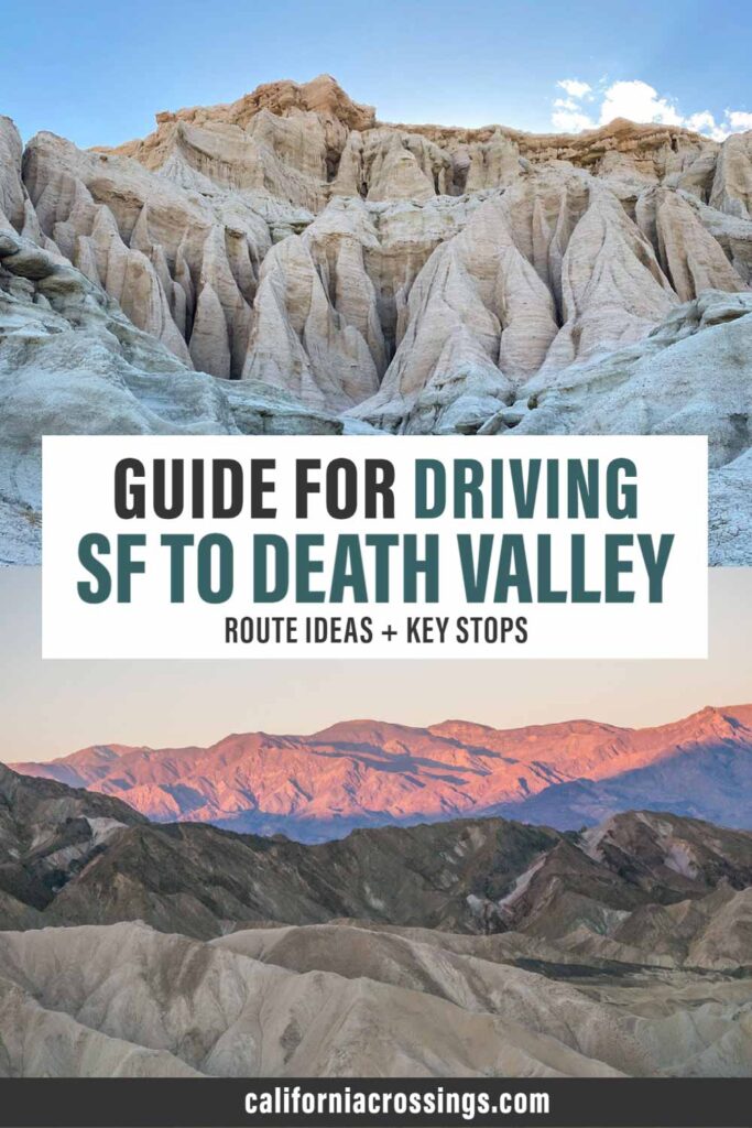
If you are embarking upon a San Francisco to Death Valley road trip, there are a couple ways that you can tackle the drive. There is no one right way to do it, but your own best route may depend upon how much time you have, the season and how keen you are to stop and smell the roses along the way.
Our recommended routing from SF to Death Valley (and back again), suggests a loop that not only gets you to the National Park in decent time, but gives you plenty of options for stopping at cool state parks and scenic sites along the way. We’ll also give you some advice for what you should do at a bare minimum, along with some additional cool ideas if you have more time.

Prepare for your San Francisco to Death Valley Drive
If you need a rental car, find your best pricing by comparing all of the different rental car providers on Rentalcars.com.
In addition to topping up your fluids and checking your tires, you may also want to bring a roadside safely kit which includes things like a warning triangle, jumper cables and the like. These kits also make a thoughtful, if tragically practical, Christmas or birthday gift. You should also pack a plug-in cooler, which uses your car’s 12 volt plug to keep lunch items and drinks cold. This will be particularly useful if it’s hot when you are in Death Valley.
You’ll encounter both California State Parks and National Parks on this SF to Death Valley drive. So, look into getting the annual California State Parks Poppy Pass (which is $125 and good at almost all CA state parks). But California also has 11 other discounted passes, so use our guide to find a park pass that is right for you.
You should also look into a National Parks annual pass ($80). In addition to the parks, it also works in National Forest fee areas and usually allows you to score a discount on campgrounds.

Google Maps is fine and all but sometimes an old school map is better for finding backroads and byways. We love the Benchmark California Road Atlas. It has a lot of detail, showing state parks and campsites as well as both paved and dirt roads.
Tips for Visiting Death Valley
For the full scoop on how to plan your trip, you should refer to our extensive Death Valley Guide. It’s gives an insane amount of detail regarding park logistics, camping, lodging, where to eat and itinerary suggestions. That said, here are some answers to commonly asked questions about the park.
Where is the Death Valley Entrance?
There is no single entrance into Death Valley, but there are three main entrances that most people use. The first is from Highway 395 through Lone Pine. The second is to come up the Panamint Valley Road from Ridgecrest. The third enters west into the park from Death Valley Junction.
The itinerary below suggests using Ridgecrest on the way in…and Lone Pine on the way out.
Is Driving in Death Valley Safe?
Yes. All of the main park sites are accessed from paved or well-graded dirt roads. There are 4×4 roads in the park, which are clearly marked on a Park Service map that you can pick up at the visitor center.
Is there Cell Service in Death Valley?
The park has very poor cell service. Your service provider may tempt you with a bar or two, but don’t plan on consistent service– certainly not in the more remote areas in the park or while hiking in the canyons. Print our guides and cache your Google maps before you go.
Is there Gas in Death Valley?
Yes. There are gas stations in Furnace Creek, Stovepipe Wells and Panamint Springs. But fill up before you go because the gas in the park is expensive and the gas stations can (and sometimes do) run out of gas.
When is the Best Time to Visit Death Valley?
The short answer is February/March for pleasant temps and (maybe) wildflowers. Mid-October through December is also very pleasant. The long answer can be found in our when to visit Death Valley article. It includes a temp and precip chart, advice on how to visit in the hotter months and more detail about less busy months.
Whatever you do, try not to go during the summer. It’s often 115′ during July and August. That sort of heat will prevent you from being able to do much of the hiking and sightseeing on this Death Valley itinerary.
Getting from San Francisco to Death Valley
Miles from SF to Death Valley: 456 miles
Active Drive Time: 7.5 hours
Routing & Stops
San Francisco south on Highway 101 to south Highway I-5 >> Cut over to Highway 43 south to Colonel Allensworth State Park >> south on Highways 99 and 58 through Tehachapi >> Highway 14 to Red Rock Canyon State Park > east to Ridgecrest then Trona Road to the Trona Pinnacles >> then north to Highway 190, stopping at Ballarat >> east into Death Valley
This routing is the fastest way to get from San Francisco to Death Valley. However, rather than bombing it down there, we suggest that you make a few pit stops along the way.
Our first suggested stop is the Colonel Allensworth State Park. This little known state park is nestled between I5 and Highway 99 just south of Fresno. The historic town was a social experiment developed in 1917 by Allensworth, who was a well respected African American civil war veteran. His vision was to develop a town specifically for African Americans where they would seek economic prosperity and control their destinies. The park shows an interesting side of California history and you can cover it in an hour.
After you round the bottom at Tahachapi, be sure to stop at Red Rock Canyon State Park. The short 1.5 mile Hagen Canyon trail is right off the road and has lovely red rocks of the sort you’d find in Utah.
Just after Ridgecrest are the little known Trona Pinnacles. These are tufa spires that just pop out of the flat landscape like popsicles. This BLM site is only a short detour off the main road. It’s a washboard dirt road. Most cars should be able to handle it, but give yourself time and patience to drive the 5 miles.
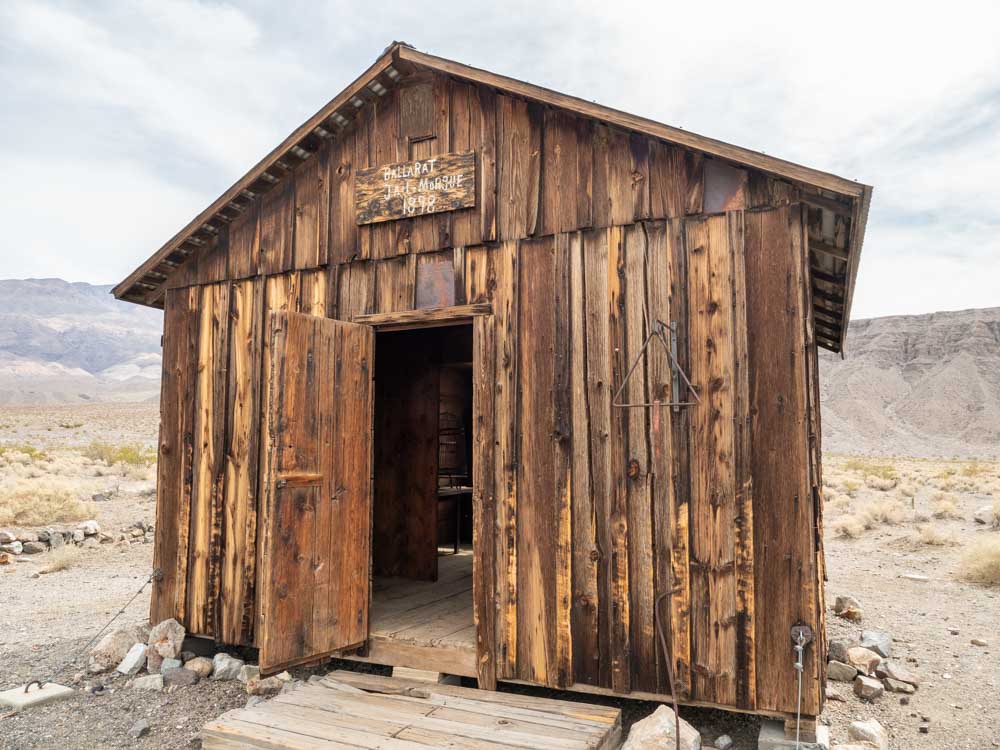
Heading north again, you’ll want to make another stop at Ballarat. This mining town outpost makes our list of the best ghost towns in California (although this whole itinerary is packed with ghost towns). It’s a small site, which you can easily cover in under an hour and it has old mining equipment, historic buildings and even Charles Manson’s truck.
Where to Stay
You can keep driving into Death Valley, but if you do even two of the suggested stops above, it will make for a very long day. So here are a few suggestions for where to spend the night outside of the park.
Camping
Red Rock Canyon has first come first served sites. There is a primitive campsite at the Trona Pinnacles. You can also do tent or RV camping at Panamint Springs.
Hotel/Motels
There are a few basic motels in Ridgecrest (Rodeway Inn, Hampton Inn etc).You can also score a glamping tent, cabin or motel room at Panamint Springs.
What to Do in Death Valley
We offer a 1-day Death Valley Itinerary and a 2-day itinerary for the park. They both cover the “must see” sites but the two day itinerary has more on it and has a less demanding pace.
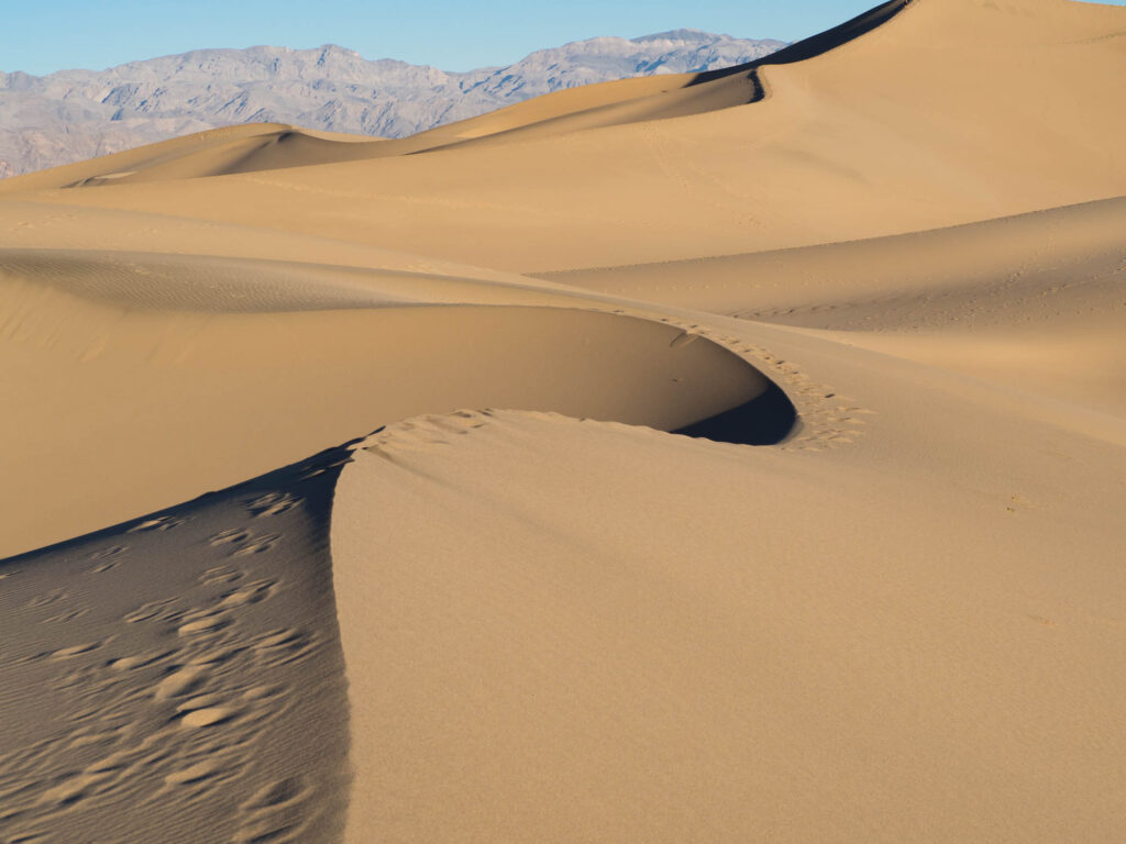
- If you only have a day: We recommend Badwater Basin, Artist Palette Drive, Zabriskie Point and Mesquite Dunes.
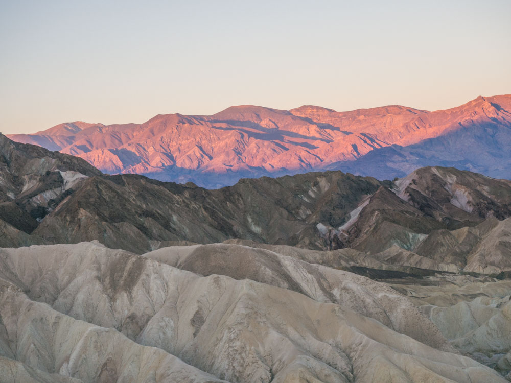
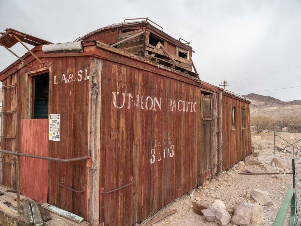
- If you have two days: Do Zabriskie Point or Mesquite Dunes at dawn, because the light is amazing. We would also add: Dante’s View, Rhyolite Ghost Town (and nearby sculptures) and the Ubehebe Crater.
- If you have three days: We recommend mixing in some hikes like: Golden Canyon/Gower Gulch, Sidewinder Canyon or Desolation Canyon. You could also squeeze in the 20-mule team drive and the Harmony Borax Works.
Where to Stay
If you want to stay inside the park, then you’ll need to plan ahead because the hotels book up early. Furnace Creek and Stovepipe Wells offer the most convenient camping and hotels for most of the park’s attractions.
Camping
There are 12 public and private campgrounds disbursed across 5,200 square miles of park. Which campground you choose will be dependent upon whether you want to be in the thick of things or out in the hinterlands. Use our Death Valley campground guide to find the right spot for you. It also has practical advice on which campgrounds require advance reservations.
Hotel/Motel
If you prefer a hotel stay, there are three hotels within the park. They range in quality and, frankly, none are a fabulous deal for the money. But if you aren’t camping, it’s worth staying at one of these three places because the nearest lodging outside of the park is 60 miles away.
Our Death Valley accommodations guide also has recommendations for budget friendly lodging outside of the park.
- The Inn at Death Valley is a fancy historic inn, with lovely grounds and a nice restaurant. Check reviews and book with Booking.com.
- The Ranch at Death Valley is a centrally located family-friendly place in Furnace Creek. Check reviews and book with Booking.com.
- The Stovepipe Wells Village Hotel is a perfectly servicable motel. They don’t have a lot of amenities, but there is a restaurant and small store onsite. Check reviews on Trip Advisor.
- If those properties are booked, or out of your price range, you can also book a basic motel in Pahrump, which is 60 miles southeast of Furnace Creek.
Getting from Death Valley to San Francisco
Miles from Death Valley to San Francisco: 460-473 miles
Active Drive Time: 8.5-9 hours
Routing & Stops
Through Yosemite: Leave Furnace Creek northeast on Highway 190 to Highway 395 > North through Lone Pine & Lee Vining > West on Highway 120 over Tioga Pass > Highway I-205 toward San Francisco
Through Tahoe: Leave Furnace Creek northeast on Highway 190 to Highway 395 > North through Lone Pine up to Carson City > West on Highway 50 through Lake Tahoe > Highway I-80 toward San Francisco
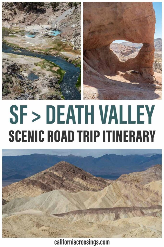
You can certainly reverse the initial routing to get home quickly(ish). But if you are willing to spend a bit of extra time, we strongly recommend returning from Death Valley to SF via Highway 395. The Eastern Sierras drive is one of our favorite scenic drives in California. But note that Tioga Pass through Yosemite is closed in the winter. So, you may need to add the extra miles and get back via Tahoe, which is also quite lovely.
If you are doing this in the fall, make sure to leave some time for exploring the fall color along 395. Our guide has specifici advice about both where and when to find turning leaves.
We have a whole huge itinerary for how to do Highway 395, so check that out for a long list of ideas and trip planning tips. But, like on the way down to Death Valley, we’ll suggest a few key stops, and most won’t take more than 1-2 hours each. You can also check out our Bishop, CA visitor guide. It covers hikes, scenic drives and historic sites around the mid-395 area. We also offer advice for some cool things to do in Lone Pine.

Hang a left in Lone Pine for a drive through the Alabama Hills. These rock formations are reminiscent of Utah and the area was popular for filming locations. Head over to the Mobius Arch loop trail for a quickie hike. The area has dirt roads but most passenger cars and RVs can easily handle it.
Back on Highway 395, be sure to stop into the Manzanar Historic Site. This federal historic monument is helping us remember the internment of Japanese-American citizens during WWII. The internment site is a sobering reminder of the civil rights crimes that we inflicted upon our own citizens.
Take another pit stop at Convict Lake. This lovely alpine lake is an easy drive off of 395 and you can have a picnic along the water and take the 2.5 mile loop around the lake. This area is particularly eye-popping in the fall.
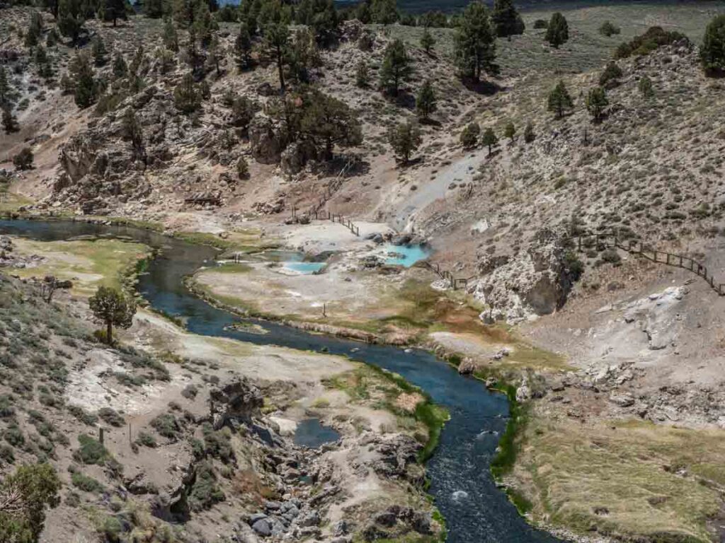
Just north of the Mammoth Airport, head east to see the Hot Creek Geologic site. The mineral water is a crazy blue color and the site sits in a lovely gorge. This is also accessed via a well-graded dirt road. You can’t soak at Hot Creek, but there are some nearby hot springs where you can take a (clothing optional) dip, like Willy’s Hot Spring and The Hot Tub.
Take a short detour off of 395 to do the scenic June Lake Loop and then head up to Lee Vining. If you have an extra 1/2 day, we strongly recommend visiting Bodie Ghost Town. It’s one of the most interesting and well-preserved ghost towns in the area. Get more info using our Bodie State Park guide.
Where to Stay
There is a wide range of Airbnbs, campground and hotel/motels stretched all along Highway 395. Unless you visit on a busy summer holiday, you should be able to find something on the fly.
Camping
The Eastern Sierras are stuffed full of forest service campgrounds. Try Bishop Creek, Rock Creek Canyon, McGee Creek, Confict Lake, Grant Lake, or Twin Lakes.
If you are RVing, you can boondock in the Alabama Hills. There are also RV parks in Lone Pine, Keogh Hot Springs, Bishop, Crawley Lake, Lee Vining and Bridgeport. But note that there are no dump sites from well south of Lone Pine until you get to Bishop, so be sure to dump in Death Valley.
Hotel/Motels
Bishop is the largest town that sits right on the highway and it’s your best option for lodging on lower 395. They have plenty of mid-range motels like Days Inn, Travelodge and Comfort Inn. Check for deals and book here. If you are on a tight budget, consider bunking at The Hostel California, it’s only $28 per bed for a mixed dorm.
Mammoth Lakes is also a good option. There are also a lot of Airbnbs and a wide range of hotels for all pricepoints.
Regardless of which San Francisco to Death Valley routing you take, you are assured of seeing some pretty stellar natural beauty. Enjoy your road trip and in the words of John Steinbeck- “A journey is a person in itself; no two are alike. And all plans, safeguards, policing, and coercion are fruitless. We find after years of struggle that we do not take a trip; a trip takes us.”
Happy trails.
Share this Death Valley to San Francisco road trip on Pinterest: