San Francisco’s trademark bridge is worth the walk for its epic views of the bay and city skyline. This local’s guide for walking the Golden Gate Bridge will give you eight practical tips (like parking and bridge hours) along with four route options that showcase the bridge from different angles.
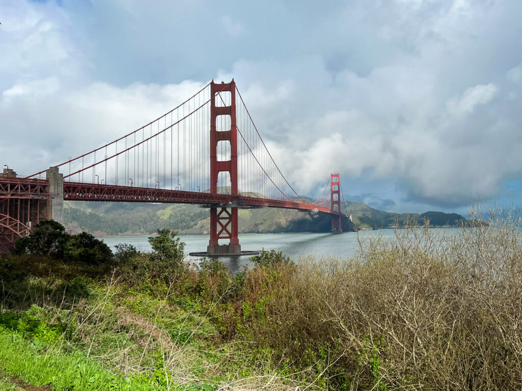
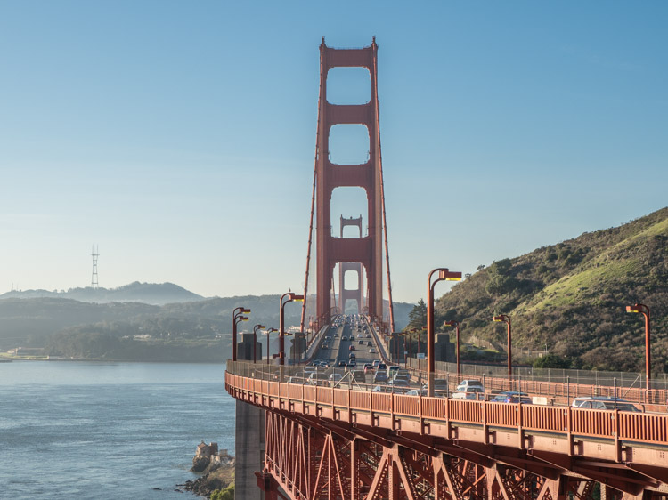
The Golden Gate Bridge is iconic not only for its distinctive red color but also for its stunning location. It’s perched at the mouth of the bay, providing a gateway to the Pacific and connecting SF with the rest of Northern California. The pop of red and graceful Art Deco design are in striking contrast to the national park lands located on either side of it.
The bridge is visible from nearly everywhere in SF, muscling itself into the skyline like a persistent photo bomber. But don’t just admire it from afar, you can also get close-up by strolling the bridge This guide for how to walk the Golden Gate Bridge is informed by my own experience as a local. I never tire of those views and after your inaugural stroll on the bridge, you won’t either.
In fact, if you are keen to do a photography shoot of the bridge or just want to see it from every angle, check out this guide to 14 awesome Golden Gate Bridge viewpoints.
This article starts by answering some commonly asked questions about how to walk the Golden Gate Bridge. Then, further down, I offer four routes for doing the bridge walk.
Read More: In addition to walking the bridge, this complete guide will help you other logistics for how to visit the bridge.
(This article contains affiliate links. This means that if you choose to purchase, I’ll make a small commission.)
Top Tips for Walking the Golden Gate Bridge
How Long is the Golden Gate Bridge?
It’s 1.7 miles one way from the Welcome Center on the south end to the vista point lookout on the north end. If you just go to the end of the bridge, but not all the way to the north side vista point, then it’s 1.3 miles one way. Check out this article on Golden Gate Bridge facts to learn more tidbits like how and when it was built and why Hollywood movies love blowing it up.
How Long Does it Take to Walk the Golden Gate Bridge?
To do the full 3.4 mile round trip, would take ~1 hour at a brisk pace and closer to 2 hours if you are stopping for pictures and to admire the view.
Are Dogs Allowed on the Bridge?
Alas, no. Only service animals are allowed on the bridge. If you are looking for a dog-friendly hike with some bridge and ocean views, we recommend the nearby Lands End hike.
Are there Pedestrian Hours for the Bridge?
Yes. Pedestrians are allowed to walk across the Golden Gate Bridge according the following seasonal schedule:
Standard Time (later November to early March): from 5am-6:30pm.
Daylight Savings Time (later March to early November): from 5am-9pm.
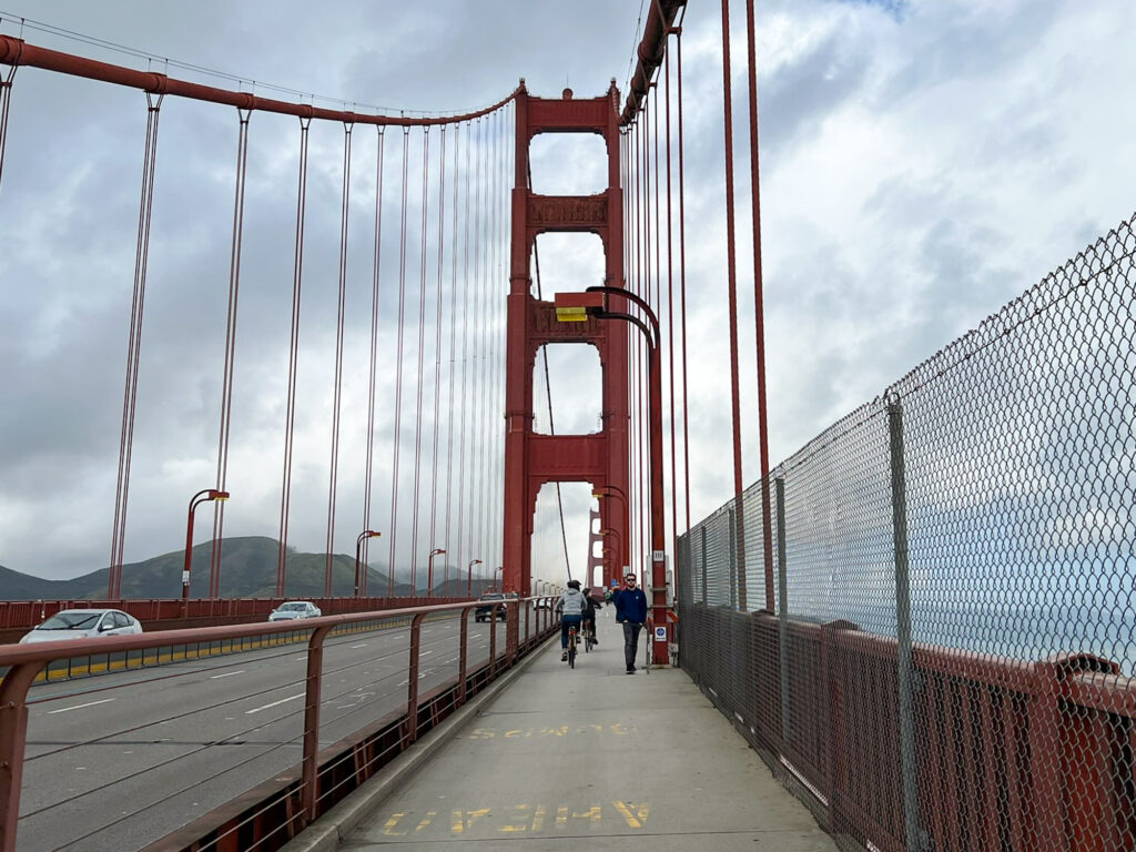
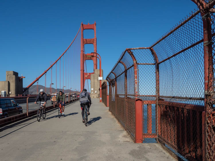
Can You Ride a Bike on the Bridge?
Yes. On weekdays after 3:30pm and on the weekends, the bikes use the west side sidewalk. However at other times, pedestrians have to share the east side walkway with the bikes, so be alert.
What Side of the Bridge Can You Walk On?
On the bridge itself, pedestrians are confined to the east side walkway. But there are several ancillary trails worth exploring, which are mentioned below.
Are There Bathrooms at the Bridge?
Yes. There are public restrooms at both the Welcome Center (south end) and the Vista Point (north end).
How Do You Get to the Golden Gate Bridge?
By Bus: If you want to take public transportation to the bridge, catch one of the following bus routes to the south end Welcome Center: From downtown and Union Square (101, 30, 70) or from Civic Center (101, 30,70, 92, 93).
By Uber: An Uber from downtown to the Welcome Center will cost ~$20 one way.
On a Sightseeing Bus: You can combine a trip to the bridge with other sightseeing using a hop on hop off pass. It will takes you on the tourist trail throughout the city. The bus stops at both the Welcome Center and the Vista Point so you can walk the bridge as a one-way. This kind of pass is only worth it if you also want to have an action packed day visiting further flung spots like Golden Gate Park and Haight Ashbury. Otherwise, just take a city bus or an Uber.
By Car: There is a small pay parking lot at the Welcome Center and a larger one just down the hill at Battery East. There is also a free parking lot at the Vista Point on the north end. Use this guide to find all of the Golden Gate Bridge parking lots.

Four Cool Routes for the Bridge Walk
When most people think of walking the Golden Gate Bridge, they are just thinking of the pedestrian walkway on the bridge itself. But if you are up for doing some additional mileage, you can take a hike to the bridge from one of several connecting pathways. These extended routes gives you more opportunity to see the bay, the Pacific and the bridge itself from different angles.
1. The Classic Walk
This is the most popular walk in SF, especially for out of town visitors. It starts at the Welcome Center at the south end of the bridge. From there, it’s 1.7 miles (one way) across the bridge to the Vista Point on the other side. There are some very nice views of San Francisco from the Vista Point. However, you don’t have to go all the way to have a nice stroll. Simply walk as far or as long as you want and then turn around.
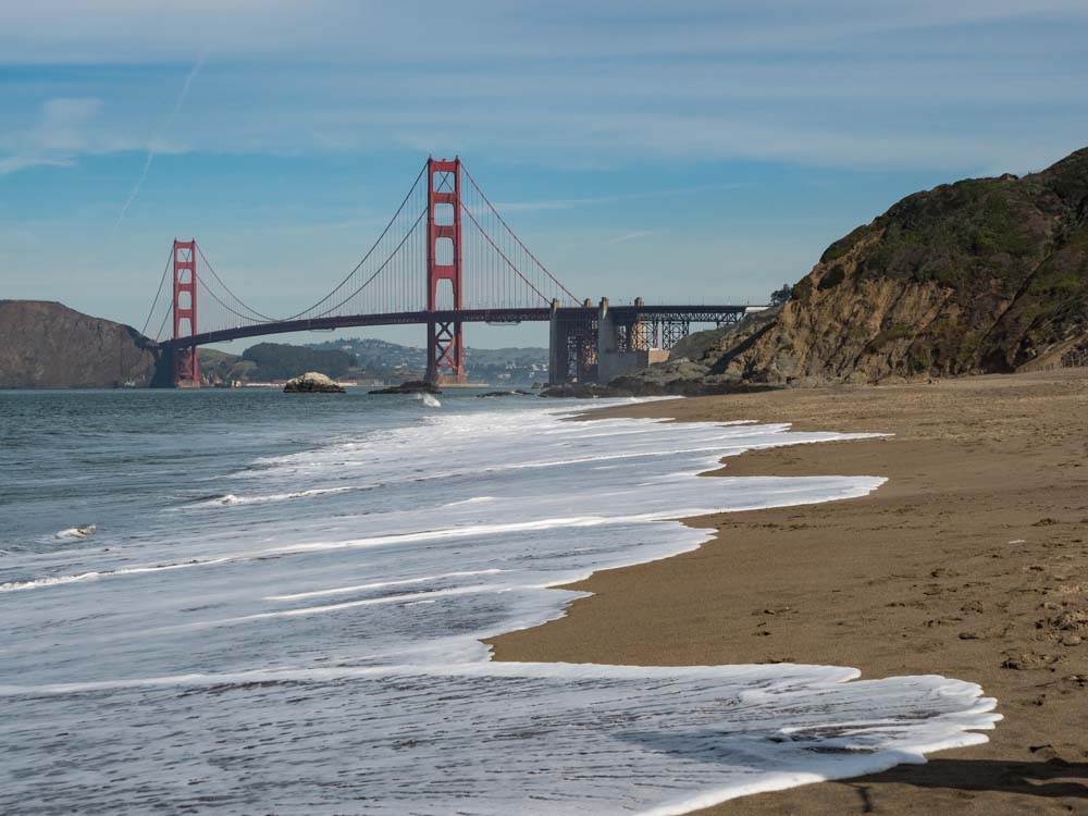
2. From Baker Beach on the Batteries to Bluffs Trail
This is fun for those interested in creeping around some of SF’s old military bunkers. And by starting at Baker Beach, you can check out one of the nicest beaches in San Francisco. It’s got a wide sand beach and great views of the bridge in the distance. From the beach, walk up to the bluffs and take the Batteries to Bluffs Trail east toward the bridge. Cross under the bridge to the Welcome Center and then continue walking on the Golden Gate Bridge.
Distance to the south end Welcome Center: 1 mile
Distance to the north end Vista Point: 2.7 miles
There is some parking at Baker beach, but public transportation would probably be more convenient.
3. From Crissy Field on the Battery East Trail
Crissy Field was once a 1920’s military airfield that is actually older than our Air Force. Over the past 20 years, it has been painstakingly reverted to it’s natural tidal marsh state and is now a popular waterfront park. Just west of Crissy Field is Fort Point, which is a civil war-era brick fort and National Historic site. Start in Crissy Field, detour down to to the fort and then backtrack up the Battery East Trail.
This trail heads up to the top of the bluff with stops for seeing more battery gun emplacements. This routing is also cool because you get interesting views of the bridge infrastructure from below. Once at the welcome center, carry on across the bridge.
Distance to the south end Welcome Center: 1.8 miles
Distance to the north end VIsta Point: 3.5 miles
There is a fairly large pay lot at Crissy field. To get there by bus from downtown, take the PresidiGo shuttle to the Main Post.
Check out our guide to hiking in the Presidio, which (in addition to Crissy Field and Batteries to Bluffs), features three more hikes.
4. Across the Bridge into Downtown Sausalito
This walk assumes that you start at the south end Welcome Center. But rather than turning around, you keep walking over the Golden Gate Bridge, down to Fort Baker and then into Sausalito. From there, you can catch a ferry back to San Francisco. The advantage of this routing is that you can wander around historic Fort Baker, get great views of Angel Island, and then you can finish up with a cold one in Sausalito. This walk is very pretty if you can time your ferry ride back to San Francisco for sunset.
If you chose this particular walk across the Golden Gate bridge, DO NOT Google map the route. It will send you down Alexander Avenue, which is a very busy road that doesn’t have proper sidewalks. Rather, you should take the more pedestrian and bike-friendly Conzelman Road.
From the north end Vista Point, take the pedway UNDER the bridge to the west side Conzelman Road trailhead parking lot. Take Conzelman south and downhill, passing through a car barrier. Then walk down, under the bridge, past the pier and into the fort. Then take East Road around the peninsula before you connect with Alexander for a short stint before heading into Sausalito proper.
Distance from the Welcome Center to the ferry dock: 4.8 miles
Check the Golden Gate Bridge transportation district or the Blue & Gold fleet for ferry schedules.
Taking a Golden Gate Bridge Tour
You can also explore more of the bridge by taking a tour. You can go on the bridge on a bike tour which takes you into Sausalito and then back to SF on the ferry. You can go under the bridge with a sunset cruise (highly recommend- drinks + sea spray). Or you can soar high above the bridge in a private helicopter tour.
However you do it, be sure to enjoy your bridge walk and make sure your phone has a lot of battery juice, because you are going to want to take a lot of pictures. Have fun and happy trails!
More Fun Things to Do in SF
- Check out our local’s guide for offbeat things to do in SF, which includes spotting Yoda, secret stairs and an adult “toy” museum.
- Our first newbie guide for SF, with practical tips and how not to look like a tourist.
- Guide for catching a ride on the cable cars (and also fun cable car facts).
- Practical tips like how to get downtown from the airport and whether you need a rental car.
- Where to stay in SF.
- Street art tour of the Mission Murals.
- Cool bookstores.
- Fun things to do in the Presidio.
This is great! I love how many details you are sharing. Such a great opportunity to get your exercise, have incredible views, and take awesome photos. I want to do it now too!
Love the detail in this guide – I’ve never actually walked the bridge but it’s been on my bucket list for a while!
This is definitely one of the things I’ve missed the most since I’ve moved out of SF! I always loved walking (or running haha) across the bridge. This is such a great guide!
Good on you for running. I definitely don’t go faster than 4MPH
A very detailed post! We will be visiting with the kids in the summer and had plans on walking the Golden Gate Bridge – thank you for sharing all the ways to walk it.
Not too far from the bridge is the Lucas Arts office building and they have a statue of Yoda and if their lobby is open you can see some of the original costumes from Star Wars- super fun for the kids (and nerds like me).
I’ve never been to the US, but this, being one of the most famous landmarks, is on my list. Thank you for this detailed guide. I would love to go on one of the walks.
I missed walking over the Golden Gate Bridge when I visited SFO. I’d also love to see it from Baker Beach. I’ll definitely be walking over it next time 🙂
Baker Beach is lovely in and of itself.
I wish I had seen this before my last visit. We did option 1 but will certainly be trying a few of these others next time!
The alternative trails are a great way to view the bridge from a distance.
I had never actually considered walking across the bridge but it seems like a good idea! Love all of the helpful tips you’ve included.
I love San Francisco so much and I still haven’t done this walk. Your post has motivated me to add it to my list for next time!
This great info! I feel like walking the Golden Gate Bridge should be a staple of visiting San Francisco. Great article!
After reading your article now I want to walk the bridge. Can you do it on Christmas Day and what is the weather like?
Yes- you can walk the bridge everyday. Weather in SF on December can be a cool 55-65. December is the start of the rainy season, so pay attention to the weather and bring a goretex coat or an umbrella.
I am walking the Golden Gates bridge for my 80th birthday. There will be about 45 of us walking. I am really excited as I have wanted to do this for some time.
Sounds like great fun!
Thank you for the specific, helpful details!
Lived there from 58′ -73′. Can’t believe that I never walked or biked across this beautiful bridge. Living in Hawaii now , but the ole saying my heart is still in the city by the bay.. Trip is planned to get back there and on the bridge.
Thkz for the information.
What a captivating account of your experience walking the iconic Golden Gate Bridge! Your vivid descriptions and personal anecdotes truly bring the journey to life for readers like me who haven’t had the chance to witness this breathtaking landmark in person. The blend of historical context, practical tips, and your own emotions made this article a delightful read. It’s evident that the Golden Gate Bridge holds a special place in your heart, and your passion shines through your writing. Thank you for sharing your adventure and inspiring us to create our own unforgettable memories on this remarkable bridge.